CONTACT US
Remote Sensing & AI Solutions
Earth Systems’ Remote Sensing and AI Solutions group delivers advanced geospatial intelligence to public and private clients nationwide. Integrating satellite and aerial remote sensing with artificial intelligence, we provide scalable, data-driven insights that help stakeholders make better environmental and resource management decisions.
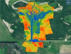
Our team uses satellite imagery from a variety of sensors to analyze large geographic areas and monitor changes over time. We apply the latest AI and machine learning technologies to extract practical insights from complex datasets—allowing us to detect patterns, identify anomalies, and track changes with precision.
Using our technology, advanced analytics and customized solutions, we can address a wide range of operational, regulatory, and research objectives with exceptional efficiency.
- Comprehensive Image Sourcing: Whatever image you need, we’ll find. Working with a wide range of public and private vendors, we do the hard work for you.
- Time-Series Monitoring: Our team makes repeated observations to track trends, detect anomalies, and assess impacts over time.
AI/ML-Augmented Analytics: We use advanced AI and machine learning to extract important deep insights that you can put into practice.
Applications
Our solutions are designed to be technically robust and operationally practical for a variety of sectors.
- Land and Resource Management: Land use change detection, encroachment identification, fire intensity analysis, and flood delineation.
- Oil and Gas: Infrastructure inventory and monitoring, environmental compliance and risk assessment, surface and subsurface releases, and encroachment monitoring.
- Environmental Monitoring: Wetland delineation and the identification of invasive, exotic, and noxious plants.
- Water and Coastal Management: Water quality parameter analysis (TSS, Chl-a), submerged aquatic vegetation delineation, and bathymetry.
- Mining: Sinkhole detection and reclamation assessments.
- Due Diligence: Historic imagery packages with integrated change detection.